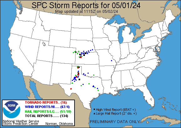
STORM REPORTS
Issued by the Storm Prediction Center

Select date for other reports

June 14, 2025

Map not available

Sort by latest Sort by occurrence Sort by severity Sort by state

70 reports sorted by the latest reports first
Jun 14   8:57 pm  CDT
OKLAHOMA   -   Washita COUNTY   -   Burns Flat
 
HAIL  -  1.00 in  -  Relayed via social media.   (Oklahoma City, OK)
 
Jun 14   8:55 pm  CDT
COLORADO   -   Morgan COUNTY   -   Fort Morgan Airport
 
WIND  -  66 mph  -    (Boulder, CO)
 
Jun 14   8:40 pm  CDT
VIRGINIA   -   Shenandoah COUNTY   -   1 MILE SOUTHWEST OF Toms Brook
 
WIND  -  Numerous roads were closed due to high water with some vehicles stranded.   (Baltimore/Washington D.C.)
 
Jun 14   8:10 pm  CDT
WYOMING   -   Campbell COUNTY   -   7 MILES SOUTHWEST OF Spotted Horse
 
HAIL  -  1.00 in  -    (Rapid City, SD)
 
Jun 14   8:06 pm  CDT
OKLAHOMA   -   Caddo COUNTY   -   4 MILES SOUTH OF Hydro
 
HAIL  -  2.00 in  -  Report from mPING: Hen Egg (2.00 in.).   (Oklahoma City, OK)
 
Jun 14   8:04 pm  CDT
OKLAHOMA   -   Caddo COUNTY   -   2 MILES EAST-SOUTHEAST OF Hydro
 
HAIL  -  1.25 in  -    (Oklahoma City, OK)
 
Jun 14   8:00 pm  CDT
OKLAHOMA   -   Caddo COUNTY   -   5 MILES EAST OF Hydro
 
HAIL  -  1.50 in  -  Report from mPING: Ping Pong Ball (1.50 in.).   (Oklahoma City, OK)
 
Jun 14   7:58 pm  CDT
MONTANA   -   Fergus COUNTY   -   8 MILES NORTH-NORTHWEST OF Moore
 
HAIL  -  1.75 in  -  Spotter reports golf ball size hail.   (Great Falls, MT)
 
Jun 14   7:56 pm  CDT
OKLAHOMA   -   Caddo COUNTY   -   1 MILE SOUTH OF Hydro
 
HAIL  -  1.75 in  -  Intersection of Highway 58 and Interstate 40.   (Oklahoma City, OK)
 
Jun 14   7:55 pm  CDT
MONTANA   -   Judith Basin COUNTY   -   4 MILES SOUTHWEST OF Hobson
 
HAIL  -  1.75 in  -  Golf ball to egg size hail reported. Additionally... hail damage to vehicle and campers was reported.   (Great Falls, MT)
 
Jun 14   7:52 pm  CDT
OKLAHOMA   -   Caddo COUNTY   -   Hydro
 
HAIL  -  2.50 in  -    (Oklahoma City, OK)
 
Jun 14   7:50 pm  CDT
OKLAHOMA   -   Caddo COUNTY   -   1 MILE WEST OF Hydro
 
HAIL  -  2.10 in  -    (Oklahoma City, OK)
 
Jun 14   7:45 pm  CDT
LOUISIANA   -   Caddo COUNTY   -   2 MILES NORTHWEST OF Hosston
 
WIND  -  Trees downed around Black Lake Hosston including near Coatney Road and Nichols Camp Road.   (Shreveport, LO)
 
Jun 14   7:45 pm  CDT
MONTANA   -   Judith Basin COUNTY   -   Hobson
 
HAIL  -  2.00 in  -  Spotter reports golf ball to egg size hail. Tree damage was also observed.   (Great Falls, MT)
 
Jun 14   7:42 pm  CDT
COLORADO   -   El Paso COUNTY   -   5 MILES SOUTH OF Colorado Springs
 
HAIL  -  1.75 in  -  hailed ranged in size from peas to golfballs.   (Pueblo, CO)
 
Jun 14   7:32 pm  CDT
WYOMING   -   Campbell COUNTY   -   5 MILES NORTH-NORTHWEST OF Dwtn Gillette
 
WIND  -  61 mph  -    (Rapid City, SD)
 
Jun 14   7:20 pm  CDT
IOWA   -   Sioux COUNTY   -   Hawarden
 
HAIL  -  1.00 in  -  Heavy rain and some strong winds as well with small twigs down and some standing water in the backyard.   (Sioux Falls, SD)
 
Jun 14   7:00 pm  CDT
COLORADO   -   El Paso COUNTY   -   1 MILE SOUTHEAST OF Manitou Springs
 
HAIL  -  1.00 in  -    (Pueblo, CO)
 
Jun 14   7:00 pm  CDT
COLORADO   -   El Paso COUNTY   -   5 MILES NORTHWEST OF Peterson AFB
 
HAIL  -  1.25 in  -    (Pueblo, CO)
 
Jun 14   6:55 pm  CDT
NEBRASKA   -   Banner COUNTY   -   14 MILES WEST OF Harrisburg
 
WIND  -  61 mph  -  Mesonet station reported wind gust of 61mph from nearby thunderstorm.   (Cheyenne, WY)
 
Jun 14   6:37 pm  CDT
COLORADO   -   El Paso COUNTY   -   6 MILES SOUTH-SOUTHEAST OF Air Force Academy
 
HAIL  -  1.00 in  -    (Pueblo, CO)
 
Jun 14   6:35 pm  CDT
SOUTH DAKOTA   -   Union COUNTY   -   8 MILES EAST-NORTHEAST OF Vermillion
 
HAIL  -  1.25 in  -    (Sioux Falls, SD)
 
Jun 14   6:26 pm  CDT
COLORADO   -   El Paso COUNTY   -   5 MILES NORTHEAST OF Manitou Springs
 
HAIL  -  1.00 in  -    (Pueblo, CO)
 
Jun 14   6:25 pm  CDT
NORTH CAROLINA   -   Alexander COUNTY   -   3 MILES WEST-NORTHWEST OF Taylorsville
 
WIND  -  Ham radio operator reported a tree blown down on power lines on Stout Farm Rd.   (Greenville/Spartanburg, SC)
 
Jun 14   6:20 pm  CDT
OKLAHOMA   -   Custer COUNTY   -   3 MILES EAST-NORTHEAST OF Thomas
 
HAIL  -  1.75 in  -    (Oklahoma City, OK)
 
Jun 14   6:20 pm  CDT
MONTANA   -   Sweet Grass COUNTY   -   12 MILES WEST-NORTHWEST OF Rapelje
 
HAIL  -  1.25 in  -    (Billings, MT)
 
Jun 14   6:15 pm  CDT
ALABAMA   -   Chambers COUNTY   -   Lafayette
 
WIND  -  Video and photos on Facebook of a woman who survived a large tree falling on her car and was able to escape without injury. Time and location approximate.   (Birmingham, AL)
 
Jun 14   6:00 pm  CDT
IOWA   -   Plymouth COUNTY   -   2 MILES NORTHEAST OF Le Mars
 
HAIL  -  1.00 in  -  Hail was observed at the golf course.   (Sioux Falls, SD)
 
Jun 14   5:56 pm  CDT
IOWA   -   Plymouth COUNTY   -   1 MILE NORTH-NORTHEAST OF Le Mars
 
HAIL  -  1.00 in  -  Significant damage to campers at the Willow Creek Campground from hail and wind driven hail. Hail lasted around 10 minutes.   (Sioux Falls, SD)
 
Jun 14   5:55 pm  CDT
IOWA   -   Plymouth COUNTY   -   1 MILE SOUTHEAST OF Le Mars
 
HAIL  -  1.25 in  -  Infrequent larger stones from quarter to half-dollar size.   (Sioux Falls, SD)
 
Jun 14   5:38 pm  CDT
ALABAMA   -   Tallapoosa COUNTY   -   3 MILES EAST-SOUTHEAST OF Jacksons' Gap
 
WIND  -  Multiple trees down across Horseshoe Bend Road near Wisel Road. ALDOT remains on scene clearing trees.   (Birmingham, AL)
 
Jun 14   5:29 pm  CDT
WEST VIRGINIA   -   Hampshire COUNTY   -   3 MILES SOUTH-SOUTHWEST OF Capon Bridge
 
WIND  -  Trees blew down in the 2900 block of CR-14 Capon River Road.   (Baltimore/Washington D.C.)
 
Jun 14   5:27 pm  CDT
ALABAMA   -   Elmore COUNTY   -   4 MILES NORTH OF Martin Dam
 
WIND  -  Report of a tree down near Ridge Marina Way.   (Birmingham, AL)
 
Jun 14   5:20 pm  CDT
MISSISSIPPI   -   Madison COUNTY   -   3 MILES SOUTHWEST OF Sharon
 
WIND  -  A tree was downed on HWY-16E as well as numerous other trees across the county.   (Jackson, MS)
 
Jun 14   5:08 pm  CDT
NORTH CAROLINA   -   Caldwell COUNTY   -   1 MILE EAST-NORTHEAST OF Lenoir
 
WIND  -  Ham radio operator reported a tree blown down at Hibriten Dr and Woodridge Dr.   (Greenville/Spartanburg, SC)
 
Jun 14   5:08 pm  CDT
VIRGINIA   -   City of Suffolk COUNTY   -   3 MILES EAST-SOUTHEAST OF Wilroy
 
WIND  -  Multiple trees knocked down along US-58 East. Time estimated from radar.   (Wakefield, VA)
 
Jun 14   5:08 pm  CDT
WEST VIRGINIA   -   Hampshire COUNTY   -   3 MILES SOUTH-SOUTHEAST OF Slanesville
 
WIND  -  Trees blew down near the intersection of CR-45/20 Cold Stream Road and CR-4/2 North River Mills Road.   (Baltimore/Washington D.C.)
 
Jun 14   4:52 pm  CDT
MISSISSIPPI   -   Hinds COUNTY   -   2 MILES NORTH-NORTHWEST OF Jackson
 
WIND  -  A tree was blown down onto powerlines on Maple Street in Jackson.   (Jackson, MS)
 
Jun 14   4:50 pm  CDT
WEST VIRGINIA   -   Berkeley COUNTY   -   1 MILE NORTH OF Ridgeway
 
WIND  -  Trees blew down in the 1900 block of CR-24/1 Sam Mason Road between I-81 and US-11 Winchester Avenue.   (Baltimore/Washington D.C.)
 
Jun 14   4:43 pm  CDT
MISSISSIPPI   -   Madison COUNTY   -   1 MILE SOUTHWEST OF Flora
 
WIND  -  Multiple trees downed.   (Jackson, MS)
 
Jun 14   4:40 pm  CDT
GEORGIA   -   Polk COUNTY   -   2 MILES SOUTH OF Antioch
 
WIND  -  Trees down along Grady and Hightower Mountain Rd.   (Atlanta, GA)
 
Jun 14   4:29 pm  CDT
ALABAMA   -   Shelby COUNTY   -   1 MILE EAST-NORTHEAST OF Columbiana
 
WIND  -  Tree reported down along Old Highway 25 near the intersection with CR 30.   (Birmingham, AL)
 
Jun 14   4:05 pm  CDT
MISSISSIPPI   -   Hinds COUNTY   -   Learned
 
WIND  -  There have been numerous reports of downed trees and a powerline across the county.   (Jackson, MS)
 
Jun 14   3:50 pm  CDT
GEORGIA   -   Polk COUNTY   -   2 MILES WEST OF Antioch
 
WIND  -  Trees down along Antioch Rd.   (Atlanta, GA)
 
Jun 14   3:47 pm  CDT
MISSISSIPPI   -   Claiborne COUNTY   -   1 MILE EAST-NORTHEAST OF Jones Village
 
WIND  -  Trees were downed at multiple locations on MS Hwy 18.   (Jackson, MS)
 
Jun 14   3:35 pm  CDT
ARKANSAS   -   Montgomery COUNTY   -   1 MILE NORTHWEST OF Mount Ida
 
WIND  -  A few trees and powerlines blown down just north of town on 270 N.   (Little Rock, AK)
 
Jun 14   3:30 pm  CDT
MISSISSIPPI   -   Claiborne COUNTY   -   3 MILES NORTH-NORTHWEST OF Pattison
 
WIND  -  Trees downed on Johnson Ln and Chicago Plantation Rd.   (Jackson, MS)
 
Jun 14   3:30 pm  CDT
MISSISSIPPI   -   Claiborne COUNTY   -   3 MILES EAST OF Grand Gulf
 
WIND  -  A tree was downed on Y Camp Rd.   (Jackson, MS)
 
Jun 14   3:25 pm  CDT
TEXAS   -   Presidio COUNTY   -   11 MILES SOUTH-SOUTHWEST OF Paisano Pass
 
WIND  -  58 mph  -  Mesonet station 156 Marfa 13SE.   (Midland/Odessa, TX)
 
Jun 14   3:18 pm  CDT
ALABAMA   -   Cherokee COUNTY   -   3 MILES NORTH-NORTHEAST OF Waterhouse
 
WIND  -  Tree down at Highway 9 and County Road 121.   (Birmingham, AL)
 
Jun 14   3:15 pm  CDT
ALABAMA   -   Jefferson COUNTY   -   1 MILE NORTH OF Liberty Park
 
WIND  -  Tree and power lines down.   (Birmingham, AL)
 
Jun 14   2:57 pm  CDT
ALABAMA   -   Cherokee COUNTY   -   1 MILE SOUTHWEST OF Centre
 
WIND  -  Tree and power line down in Centre.   (Birmingham, AL)
 
Jun 14   2:50 pm  CDT
MISSISSIPPI   -   Lamar COUNTY   -   1 MILE EAST OF Oak Grove
 
WIND  -  A utility pole was downed blocking traffic near the intersection of Oak Grove Rd and Griffith Rd.   (Jackson, MS)
 
Jun 14   2:30 pm  CDT
FLORIDA   -   Alachua COUNTY   -   5 MILES NORTH OF Archer
 
WIND  -  Fallen tree on SW 170th Street lead to temporarily closure. Time based off radar and report.   (Jacksonville, FL)
 
Jun 14   2:27 pm  CDT
MISSISSIPPI   -   Covington COUNTY   -   1 MILE SOUTHEAST OF Lone Star
 
WIND  -  A tree was downed across Blackjack Rd blocking traffic.   (Jackson, MS)
 
Jun 14   2:05 pm  CDT
VIRGINIA   -   Henry COUNTY   -   3 MILES SOUTH-SOUTHWEST OF Martinsville City
 
WIND  -  Henry County 911 Call Center reported a tree down blocking one lane on Cameron Road in Martinsville... VA.   (Roanoke, VA)
 
Jun 14   1:28 pm  CDT
NORTH CAROLINA   -   Yadkin COUNTY   -   1 MILE NORTH OF Yadkinville
 
WIND  -  Tree down... blocking one lane of Country Club Road.   (Roanoke, VA)
 
Jun 14   1:18 pm  CDT
NORTH CAROLINA   -   Surry COUNTY   -   1 MILE EAST-NORTHEAST OF Siloam
 
WIND  -  Delayed Report: Surry County 911 Call Center reported that two trees are down on Hardy Road in Siloam... NC. Time is estimated from radar.   (Roanoke, VA)
 
Jun 14   1:05 pm  CDT
OKLAHOMA   -   Pontotoc COUNTY   -   4 MILES EAST OF Ada
 
HAIL  -  1.00 in  -  Report from mPING: Quarter (1.00 in.).   (Oklahoma City, OK)
 
Jun 14   1:00 pm  CDT
NORTH CAROLINA   -   Surry COUNTY   -   2 MILES EAST-NORTHEAST OF Fairview
 
WIND  -  Delayed Report: Surry County 911 Call Center reported a tree fell across Rockford Road near Dobson... blocking both lanes. Time is estimated from radar.   (Roanoke, VA)
 
Jun 14   1:00 pm  CDT
NORTH CAROLINA   -   Surry COUNTY   -   2 MILES SOUTH-SOUTHEAST OF Flat Rock
 
WIND  -  Surry County 911 Call Center reported a tree down near the intersection of Massey Road and Saint Marie Trail in Mount Airy... NC. Time is estimated from radar.   (Roanoke, VA)
 
Jun 14   12:40 pm  CDT
OKLAHOMA   -   Hughes COUNTY   -   4 MILES SOUTH-SOUTHEAST OF Holdenville
 
WIND  -  Tree blown down at Holdenville Lake. Time estimated from radar.   (Oklahoma City, OK)
 
Jun 14   12:00 pm  CDT
LOUISIANA   -   Livingston COUNTY   -   1 MILE NORTHEAST OF Walker
 
WIND  -  Tree down on Moore Ave in Walker.   (New Orleans/Baton Rouge, LO)
 
Jun 14   11:45 am  CDT
FLORIDA   -   Alachua COUNTY   -   7 MILES WEST OF University of Flori
 
WIND  -  Road closed at the intersection of W Newberry Rd and NW 120th Terrace in Gainesville due to a fallen tree and downed power lines. Time est. based off radar.   (Jacksonville, FL)
 
Jun 14   9:15 am  CDT
KANSAS   -   Cowley COUNTY   -   Udall
 
WIND  -  60 mph  -    (Wichita, KS)
 
Jun 14   9:04 am  CDT
KANSAS   -   Sumner COUNTY   -   5 MILES WEST-NORTHWEST OF Udall
 
WIND  -  70 mph  -    (Wichita, KS)
 
Jun 14   8:05 am  CDT
KANSAS   -   McPherson COUNTY   -   5 MILES WEST-NORTHWEST OF Moundridge
 
WIND  -  65 mph  -    (Wichita, KS)
 
Jun 14   7:51 am  CDT
KANSAS   -   Reno COUNTY   -   5 MILES NORTH-NORTHEAST OF Hutchinson
 
WIND  -  63 mph  -    (Wichita, KS)
 
Jun 14   7:46 am  CDT
KANSAS   -   Reno COUNTY   -   KHUT
 
WIND  -  62 mph  -    (Wichita, KS)
 
Jun 14   7:27 am  CDT
KANSAS   -   Reno COUNTY   -   3 MILES WEST-SOUTHWEST OF Langdon
 
WIND  -  60 mph  -    (Wichita, KS)
 
Daily reports from the Storm Prediction Center starts at noon UTC and ends at one minute before noon UTC the next day. This time period is between 7am CDT and one minute before 7am CDT the next day.
All reports are considered preliminary and should be treated as such.